


Pergamon Ancient City or Pergamum Ancient City, also referred to by its modern Greek form Pergamos was a rich and powerful ancient Greek city in Mysia. It is located 26 kilometres (16 mi) from the modern coastline of the Aegean Sea on a promontory on the north side of the river Caicus (modern-day Bakırçay) and northwest of the modern city of Bergama, Turkey.
During the Hellenistic period, it became the capital of the Kingdom of Pergamon Ancient City in 281–133 BC under the Attalid dynasty, who transformed it into one of the major cultural centres of the Greek world. Many remains of its monuments can still be seen and especially the masterpiece of the Pergamon Altar. Pergamon Ancient City was the northernmost of the seven churches of Asia cited in the New Testament Book of Revelation.
The city is centered on a 335-metre-high (1,099 ft) mesa of andesite, which formed its acropolis. This mesa falls away sharply on the north, west, and east sides, but three natural terraces on the south side provide a route up to the top. To the west of the acropolis, the Selinus River (modern Bergamaçay) flows through the city, while the Ketios river (modern Kestelçay) passes by to the east.
Pergamon Ancient City was added to the UNESCO World Heritage List in 2014.
Pergamon Ancient City Location
Pergamon Ancient City lies on the north edge of the Caicus plain in the historic region of Mysia in the northwest of Turkey. The Caicus river breaks through the surrounding mountains and hills at this point and flows in a wide arc to the southwest. At the foot of the mountain range to the north, between the rivers Selinus and Cetius, there is the massif of Pergamon which rises 335 metres above sea level. The site is only 26 km from the sea, but the Caicus plain is not open to the sea, since the way is blocked by the Karadağ massif. As a result, the area has a strongly inland character. In Hellenistic times, the town of Elaia at the mouth of the Caicus served as the port of Pergamon. The climate is Mediterranean with a dry period from May to August, as is common along the west coast of Asia Minor.
The Caicus valley is mostly composed of volcanic rock, particularly andesite and the Pergamon massif is also an intrusive stock of andesite. The massif is about one kilometre wide and around 5.5 km long from north to south. It consists of a broad, elongated base and a relatively small peak – the upper city. The side facing the Cetius river is a sharp cliff, while the side facing the Selinus is a little rough. On the north side, the rock forms a 70 m wide spur of rock. To the southeast of this spur, which is known as the ‘Garden of the Queen’, the massif reaches its greatest height and breaks off suddenly immediately to the east. The upper city extends for another 250 m to the south, but it remains very narrow, with a width of only 150 m. At its south end the massif falls gradually to the east and south, widening to around 350 m and then descends to the plain towards the southwest.
Pergamon Ancient City in Myth
Pergamon, which traced its founding back to Telephus, the son of Heracles, is not mentioned in Greek myth or epic of the archaic or classical periods. However, in the Epic Cycle the Telephus myth is already connected with the area of Mysia. Searching for his mother, Telephus visits Mysia on the advice of an oracle. There he becomes Teuthras’ son-in-law or foster-son and inherits his kingdom of Teuthrania, encompassing the area between Pergamon and the mouth of the Caicus. Telephus refuses to participate in the Trojan War, but his son Eurypylus fights on the side of the Trojans. This material was dealt with in a number of tragedies, such as Aeschylus’ Mysi, Sophocles’ Aleadae, and Euripides’ Telephus and Auge, but Pergamon does not seem to have played any role in any of them. The adaptation of the myth is not entirely smooth.
Thus, on the one hand, Eurypylus who must have been part of the dynastic line as a result of the appropriation of the myth, was not mentioned in the hymn sung in honour of Telephus in the Asclepieion. Otherwise he does not seem to have been paid any heed. But the Pergamenes made offerings to Telephus and the grave of his mother Auge was located in Pergamon near the Caicus. Pergamon thus entered the Trojan epic cycle, with its ruler said to have been an Arcadian who had fought with Telephus against Agamemnon when he landed at the Caicus, mistook it for Troy and began to ravage the land.
On the other hand, the story was linked to the foundation of the city with another myth – that of Pergamus, the eponymous hero of the city. He also belonged to the broader cycle of myths related to the Trojan War as the grandson of Achilles through his father Neoptolemus and of Eetion of Thebe through his mother Andromache (concubine to Neoptolemus after the death of Hector of Troy). With his mother, he was said to have fled to Mysia where he killed the ruler of Teuthrania and gave the city his own name. There he built a heroon for his mother after her death. In a less heroic version, Grynos the son of Eurypylus named a city after him in gratitude for a favour. These mythic connections seem to be late and are not attested before the 3rd century BC. Pergamus’ role remained subordinate, although he did receive some cult worship. Beginning in the Roman period, his image appears on civic coinage and he is said to have had a heroon in the city. Even so, he provided a further, deliberately crafted link to the world of Homeric epic. Mithridates VI was celebrated in the city as a new Pergamus.
However, for the Attalids, it was apparently the genealogical connection to Heracles that was crucial, since all the other Hellenistic dynasties had long established such links: the Ptolemies derived themselves directly from Heracles, the Antigonids inserted Heracles into their family tree in the reign of Philip V at the end of the 3rd century BC at the latest, and the Seleucids claimed descent from Apollo. All of these claims derive their significance from Alexander the Great, who claimed descent from Heracles, through his father Philip II.
In their constructive adaptation of the myth, the Attalids stood within the tradition of the other, older Hellenistic dynasties, who legitimized themselves through divine descent, and sought to increase their own prestige. The inhabitants of Pergamon enthusiastically followed their lead and took to calling themselves Telephidai (Τηλεφίδαι) and referring to Pergamon itself in poetic registers as the ‘Telephian city’
Infrastructure and housing
Pergamon is a good example of a city that expanded in a planned and controlled manner. Philetairos transformed Pergamon from an archaic settlement into a fortified city. He or his successor Attalos I built a wall around the whole upper city, including the plateau to the south, the upper agora and some of the housing – further housing must have been found outside these walls. Because of the growth of the city, the streets were expanded and the city was monumentalised. Under Attalos I some minor changes were made to the city of Philetairos. During the reign of Eumenes II and Attalos II, there was a substantial expansion of the city. A new street network was created and a new city wall, with a monumental gatehouse called the Gate of Eumenes, was built south of the Acropolis. The wall, with numerous gates, now surrounded the entire hill, not just the upper city and the flat area to the southwest, all the way to the Selinus river. Numerous public buildings were constructed, as well as a new marketplace south of the acropolis and a new gymnasion in the east. The southeast slope and the whole western slope of the hill were now settled and opened up by streets.
The plan of Pergamon was affected by the extreme steepness of the site. As a result of this, the streets had to turn hairpin corners, so that the hill could be climbed as comfortably and quickly as possible. For the construction of buildings and laying out of the agoras, extensive work on the cliff-face and terracing had to be carried out. A consequence of the city’s growth was the construction of new buildings over old ones, since there was not sufficient space.
Separate from this, a new area was laid out in Roman times, consisting of a whole new city west of the Selinus river, with all necessary infrastructure, including baths, theatres, stadiums, and sanctuaries. This Roman new city was able to expand without any city walls constraining it because of the absence of external threats.
Housing
Generally, most of the Hellenistic houses at Pergamon were laid out with a small, centrally-located and roughly square courtyard, with rooms on one or two sides of it. The main rooms are often stacked in two levels on the north side of the courtyard. A wide passage or colonnade on the north side of the courtyard often opened onto foyers, which enabled access to other rooms. An exact north-south arrangement of the city blocks was not possible because of the topographical situation and earlier construction. Thus the size and arrangement of the rooms differed from house to house. From the time of Philetairos, at the latest, this kind of courtyard house was common and it was ever more widespread as time went on, but not universal. Some complexes were designed as Prostas houses, similar to designs seen at Priene. Others had wide columned halls in front of main rooms to the north. Especially in this latter type there is often a second story accessed by stairways. In the courtyards there were often cisterns, which captured rain water from the sloping roofs above. For the construction under Eumenes II, a city block of 35 x 45 m can be reconstructed, subject to significant variation as a result of the terrain.
Open spaces
From the beginning of the reign of Philetairos, civic events in Pergamon were concentrated on the Acropolis. Over time the so-called ‘Upper agora’ was developed at the south end of this. In the reign of Attalos I, a Temple of Zeus was built there. To the north of this structure there was a multi-story building, which propbably had a function connected to the marketplace. With progressive development of the open space, these buildings were demolished, while the Upper Agora itself took on a more strongly commercial function, while still a special space as a result of the temple of Zeus. In the course of the expansion of the city under Eumenes, the commercial character of the Upper Agora was further developed. The key signs of this development are primarily the halls built under Eumenes II, whose back chambers were probably used for trade. In the west, the ‘West Chamber’ was built which might have served as a market administration building. After these renovations, the Upper Agora thus served as a centre for trade and spectacle in the city.
Because of significant new construction in the immediate vicinity – the renovation of the Sanctuary of Athena and the Pergamon altar and the redesign of the neighbouring area – the design and organisational principle of the Upper Agora underwent a further change. Its character became much more spectacular and focussed on the two new structures looming over it, especially the altar which was visible on its terrace from below since the usual stoa surrounding it was omitted from the design.
The 80 m long and 55 m wide ‘Lower Agora’ was built under Eumenes II and was not significantly altered until Late Antiquity. As with the Upper Agora, the rectangular form of the agora was adapted to the steep terrain. The construction consisted in total of three levels. Of these the Upper Level and the ‘Main Level’ opened onto a central courtyard. On the lower level there were rooms only on the south and east sides because of the slope of the land, which led through a colonnade to the exterior of the space. The whole market area extended over two levels with a large columned hall in the centre, which contained small shop spaces and miscellaneous rooms.
Streets and bridges
The course of the main street, which winds up the hill to the Acropolis with a series of hairpin turns, is typical of the street system of Pergamon. On this street were shops and warehouses. The surface of the street consisted of andesite blocks up to 5 metres wide, 1 metre long and 30 cm deep. The street included a drainage system, which carried the water down the slope. Since it was the most important street of the city, the quality of the material used in its construction was very high.
The nearly 200 metre wide Pergamon Bridge under the forecourt of the Red Basilica in the centre of Bergama is the largest bridge substruction from antiquity.
Water supply
The inhabitants of Pergamon were supplied with water by an effective system. In addition to cisterns, there was a system of nine pipes (seven Hellenistic ceramic pipes and two open Roman channels. The system provided around 30,000–35,000 cubic metres of water per day.
The Madradağ aqueduct was a ceramic pipe with a diameter of 18 cm which already brought water to the citadel from a source over 40 kilometres away in the Madradağ mountains at 1174 m above sea level in the Hellenistic period. Their significance for architectural history lies in the form of the last kilometres from the mountains through a 200-metre-deep (660 ft) valley to the Akropolis. The pipe consisted of three channels, which ended 3 km north of the citadel, before reaching the valley, and emptied into a pool, which included a double sedimentation tank. This pool was 35 metres higher than the summit of the citadel. The pipe from the pool to the Acropolis consisted of only a single channel – a lead pipe pressurised to 200 mH2O. The water was able to cross the valley between the pool and the citadel with the help of this pressurised conduit. It functioned as a communicating vessel, such that the water rose to the height of the citadel on its own as a result of the pressurised pipe.
Pergamon Ancient City Main sights
Pergamon Ancient City Upper Acropolis
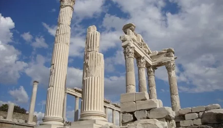
Pergamon Altar
The most famous structure from the city is the monumental altar, which was probably dedicated to Zeus and Athena. The foundations are still located in the Upper city, but the remains of the Pergamon frieze, which originally decorated it, are displayed in the Pergamon museum in Berlin, where the parts of the frieze taken to Germany have been installed in a partial reconstruction.
In the New Testament Book of Revelation, the faith of the Pergamon believers, who “dwell where Satan’s throne is” is commended by the author. Many scholars believe that the “seat of Satan” refers to the Pergamon Altar, due to its resemblance to a gigantic throne.
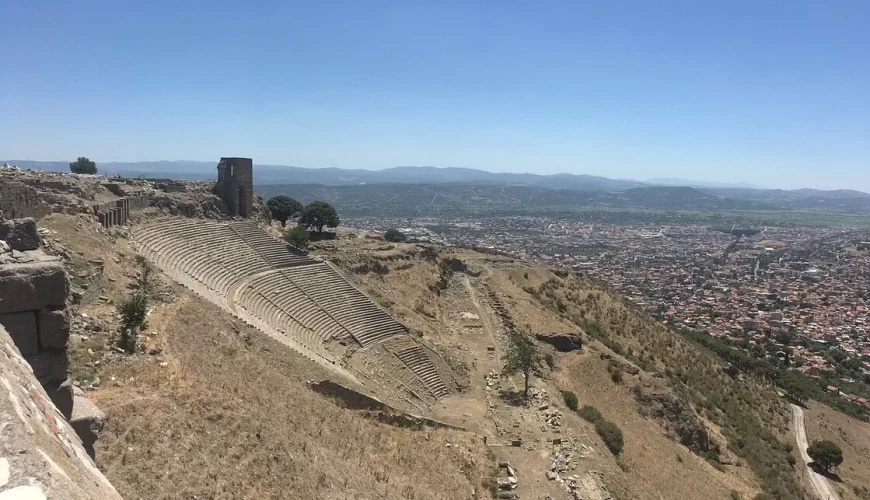
Theatre
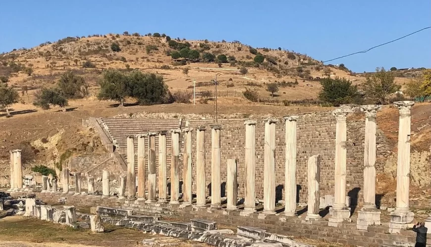
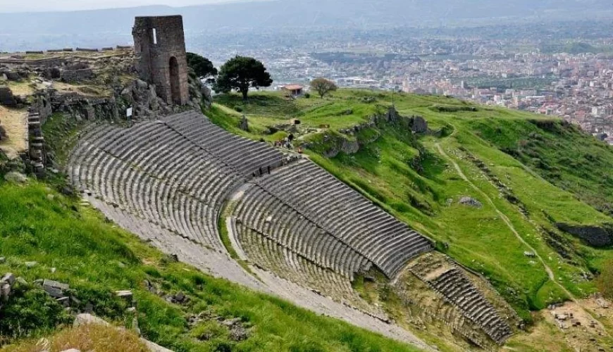
The well-preserved Theatre of Pergamon dates from the Hellenistic period and had space for around 10,000 people, in 78 rows of seats. At a height of 36 metres, it is the steepest of all ancient theatres. The seating area (koilon) is divided horizontally by two walkways, called diazomata, and vertically by 0.75-metre-wide (2.5 ft) stairways into seven sections in the lowest part of the theatre and six in the middle and upper sections. Below the theatre is a 247-metre-long (810 ft) and up to 17.4-metre-wide (57 ft) terrace, which rested on a high retaining wall and was framed on the long side by a stoa. Coming from the Upper market, one could enter this from a tower-building at the south end. This terrace had no space for the circular orchestra, which was normal in a Greek theatre, so only a wooden stage building was built which could be taken down when there was no performance taking place. Thus, the view along the terrace to the Temple of Dionysos at the northern end was unimpeded. A marble stage building was only built in the 1st century BC. Additional theatres were built in the Roman period, one in the Roman new city and the other in the sanctuary of Asclepius.
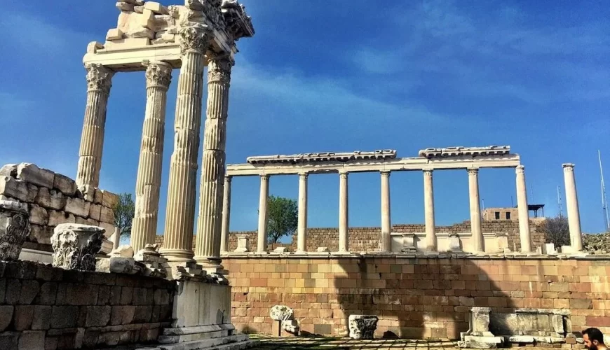
Trajaneum
On the highest point of the citadel is the Temple for Trajan and Zeus Philios. The temple sits on a 2.9-metre-high (9.5 ft) podium on top of a vaulted terrace. The temple itself was a Corinthian peripteros temple, about 18 metres wide with six columns on the short sides and nine columns on the long sides, and two rows of columns in antis. To the north, the area was closed off by a high stoa, while on the west and east sides it was surrounded by simple ashlar walls, until further stoas were inserted in Hadrian’s reign.
During the excavations fragments of statues of Trajan and Hadrian were found in the rubble of the cella, including their portrait heads, as well as fragments of the cult statue of Zeus Philios.
Temple of Dionysus
At Pergamon, Dionysus had the epithet Kathegemon, ‘the guide’, and was already worshiped in the last third of the 3rd century BC, when the Attalids made him the chief god of their dynasty. In the 2nd century BC, Eumenes II (probably) built a temple for Dionysus at the northern end of the theatre terrace. The marble temple sits on a podium, 4.5 metres above the level of the theatre terrace and was an Ionic prostyle temple. The pronaos was four columns wide and two columns deep and was accessed by a staircase of twenty-five steps. Only a few traces of the Hellenistic structure survive. The majority of the surviving structure derives from a reconstruction of the temple which probably took place under Caracalla, or perhaps under Hadrian.
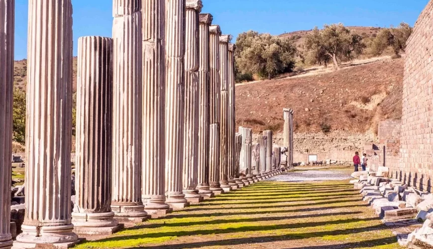
Temple of Athena
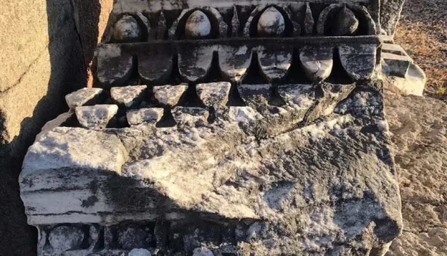
Pergamon’s oldest temple is a sanctuary of Athena from the 4th century BC. It was a north-facing Doric peripteros temple with six columns on the short side and ten on the long side and a cella divided into two rooms. The foundations, measuring around 12.70 x 21.80 metres, are still visible today. The columns were around 5.25 metres high, 0.75 metres in diameter, and the distance between the columns was 1.62 metres, so the colonnade was very light for a temple of this period. This is matched by the shape of the triglyphs, which usually consist of a sequence of two triglyphs and two metopes, but are instead composed of three of triglyphs and three metopes. The columns of the temple are unfluted and retained bossage, but it is not clear whether this was a result of carelessness or incompleteness.
A two-story stoa surrounding the temple on three sides was added under Eumenes II, along with the propylon in the southeast corner, which is now found, largely reconstructed, in the Pergamon Museum in Berlin. The balustrade of the upper level of the north and east stoas was decorated with reliefs depicting weapons which commemorated Eumenes II’s military victory. The construction mixed Ionic columns and Doric triglyphs (of which five triglyphs and metopes survive). In the area of the sanctuary, Attalos I and Eumenes II constructed victory monuments, most notably the Gallic dedications. The northern stoa seems to have been the site of the Library of Pergamon.
Library
The Library of Pergamon was the second largest in the ancient Greek world after the Library of Alexandria, containing at least 200,000 scrolls. The location of the library building is not certain. Since the 19th century excavations, it has generally been identified with an annex of the northern stoa of the sanctuary of Athena in the Upper Citadel, which was built by Eumenes II. Inscriptions in the gymnasium which mention a library might indicate, however, that the building was located in that area.
Other structures
Other notable structures still in existence on the upper part of the Acropolis include:
- The Royal palaces
- The Heroön – a shrine where the kings of Pergamon, particularly Attalus I and Eumenes II, were worshipped.
- The Upper Agora
- The Roman baths complex
- Diodorus Pasporos heroon
- Arsenals
The site is today easily accessible by the Bergama Acropolis Gondola from the base station in northeastern Bergama.
Pergamon Ancient City Lower Acropolis
Gymnasium
A large gymnasium area was built in the 2nd century BC on the south side of the Acropolis. It consisted of three terraces, with the main entrance at the southeast corner of the lowest terrace. The lowest and southernmost terrace is small and almost free of buildings. It is known as the Lower Gymnasium and has been identified as the boys’ gymnasium. The middle terrace was around 250 metres long and 70 metres wide at the centre. On its north side there was a two-story hall. In the east part of the terrace there was a small prostyle temple in the Corinthian order. A roofed stadium, known as the Basement Stadium is located between the middle terrace and the upper terrace.
The upper terrace measured 150 x 70 metres square, making it the largest of the three terraces. It consisted of a courtyard surrounded by stoas and other structures, measuring roughly 36 x 74 metres. This complex is identified as a palaestra and had a theatre-shaped lecture hall beyond the northern stoa, which is probably of Roman date and a large banquet hall in the centre. Further rooms of uncertain function were accessible from the stoas. In the west was a south-facing Ionic antae temple, the central sanctuary of the gymnasium. The eastern area was replaced with a bath complex in Roman times. Further Roman baths were constructed to the west of the Ionic temple.
Sanctuary of Hera
The sanctuary of Hera Basileia (‘the Queen’) lay north of the upper terrace of the gymnasium. Its structure sits on two parallel terraces, the south one about 107.4 metres above sea level and the north one about 109.8 metres above sea level. The Temple of Hera sat in the middle of the upper terrace, facing to the south, with a 6-metre-wide (20 ft) exedra to the west and a building whose function is very unclear to the east. The two terraces were linked by a staircase of eleven steps around 7.5 metres wide, descending from the front of the temple.
The temple was about 7 metres wide by 12 metres long, and sat on a three-stepped foundation. It was a Doric tetrastyle prostyle temple, with three triglyphs and metopes for each span in the entablature. All the other buildings in the sanctuary were made out of trachyte, but the visible part of the temple was made of marble, or at least had a marble cladding. The base of the cult image inside the cella supported three cult statues.
The surviving remains of the inscription on the architrave indicate that the building was the temple of Hera Basileia and that it was erected by Attalus II.
Sanctuary of Demeter
The Sanctuary of Demeter occupied an area of 50 x 110 metres on the middle level of the south slope of the citadel. The sanctuary was old; its activity can be traced back to the fourth century BC.
The sanctuary was entered through a Propylon from the east, which led to a courtyard surrounded by stoas on three sides. In the centre of the western half of this courtyard, stood the Ionic temple of Demeter, a straightforward Antae temple, measuring 6.45 x 12.7 metres, with a porch in the Corinthian order which was added in the time of Antoninus Pius. The rest of the structure was of Hellenistic date, built in local marble and had a marble frieze decorated with bucrania. About 9.5 metres in front of the east-facing building, there was an altar, which was 7 metres long and 2.3 metres wide. The temple and the altar were built for Demeter by Philetaerus, his brother Eumenes, and their mother Boa.
In the east part of the courtyard, there were more than ten rows of seating laid out in front of the northern stoa for participants in the mysteries of Demeter. Roughly 800 initiates could fit in these seats.
Other structures
The lower part of the Acropolis also contains the following structures:
- the House of Attalus
- the Lower Agora and
- the Gate of Eumenes
Pergamon Ancient City At the foot of the Acropolis
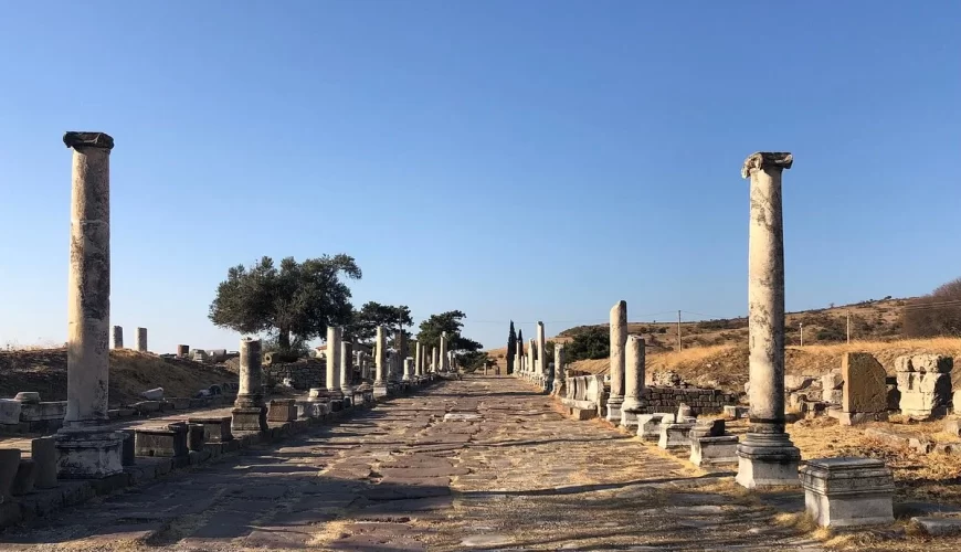
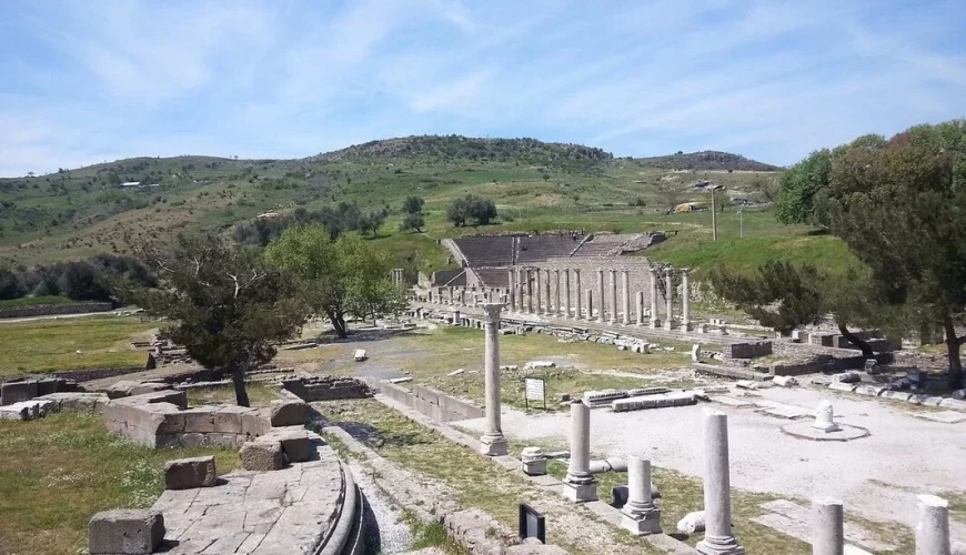
Sanctuary of Asclepius
Three kilometres (1.9 miles) south of the Acropolis at (39° 7′ 9″ N, 27° 9′ 56″ E), down in the valley, there was the Sanctuary of Asclepius (also known as the Asclepium), the god of healing. The Asclepium was approached along an 820-meter colonnaded sacred way. In this place people with health problems could bathe in the water of the sacred spring, and in the patients’ dreams Asclepius would appear in a vision to tell them how to cure their illness. Archeology has found many gifts and dedications that people would make afterwards, such as small terracotta body parts, no doubt representing what had been healed. Galen, the most famous doctor in the ancient Roman Empire and personal physician of Emperor Marcus Aurelius, worked in the Asclepium for many years. Notable extant structures in the Asclepium include:
- the Roman theater
- the North Stoa
- the South Stoa
- the Temple of Asclepius
- a circular treatment center (sometimes known as the Temple of Telesphorus)
- a healing spring
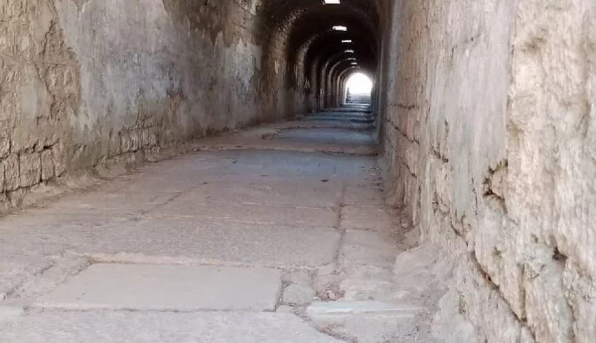
- an underground passageway
- a library
- the Via Tecta (or the Sacred Way, which is a colonnaded street leading to the sanctuary) and
- a propylon
Pergamon Ancient City Serapis Temple
Pergamon Ancient City other notable structure is the great temple of the Egyptian gods Isis and/or Serapis, known today as the “Red Basilica” (or Kızıl Avlu in Turkish), about one kilometre (0.62 miles) south of the Acropolis at (39 7′ 19″ N, 27 11′ 1″ E). It consists of a main building and two round towers within an enormous temenos or sacred area. The temple towers flanking the main building had courtyards with pools used for ablutions at each end, flanked by stoas on three sides. The forecourt of the Temple of Isis/Sarapis is still supported by the 193-metre-wide (633-foot) Pergamon Ancient City Bridge, the largest bridge substruction of antiquity.
According to Christian tradition, in the year 92 Saint Antipas, the first bishop of Pergamum ordained by John the Apostle, was a victim of an early clash between Serapis worshippers and Christians. An angry mob is said to have burned Saint Antipas alive in front of the Temple inside a brazen bull-like incense burner, which represented the bull god Apis. His martyrdom is one of the first recorded in Christian history, highlighted by the Christian Scripture itself through the message sent to the Pergamon Ancient City Church in the Book of Revelation.
Comment (0)